Click each project title to expand the project details.
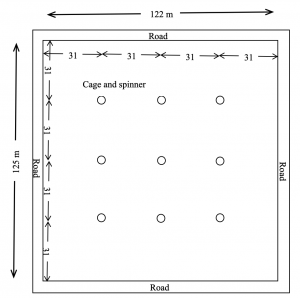
SMART BIO-ASSAY CAGE DEVELOPMENT FOR EVALUATION OF EFFICACY OF MOSQUITO CONTROL ADULTICIDES
Nelms Institute Contact: William Eisenstadt
The proposed work will develop a smart sensor and bioassay cage prototypes that will be evaluated in a field environment to demonstrate that the developed products can measure the efficacy of the mosquito adulticide application. This work is unique in that it enables the research collaboration between the entomologists, biologists from Anastasia Mosquito Control District (AMCD) and electronics and sensor experts (University of Florida, Dept of ECE). The work will develop a prototype smart mosquito sensor and bioassay cage that, 1) evaluates the properties of insect spray aerosols, 2) records environmental information at the time of spraying such as temperature, humidity and location, and 3) reports the information wirelessly to a cell phone or a computer. The work will compare the newly developed smart bioassay cage to existing techniques for mosquito cage spray evaluation and build a cross-reference guide.
DARLING – DRONE-BASED ADMINISTRATION OF REMOTELY LOCATED INSTRUMENTS AND GEARS
Nelms Institute Contact: Swarup Bhunia
This work is about a framework for assisting remote devices using an Unmanned Aerial Vehicle (UAV). The DARLING architecture has three hardware components: the UAV, a base station which is responsible for housing the UAV, and remote devices which the UAV services. We describe all the parts needed for the base station and the UAVs in order to carry out a smooth, remote maintenance procedure. Whenever it is unsafe for the UAV to land near the remote device, we propose the use of a Detachable Charging Unit (DCU) which has a platform that carries a battery pack and connects to the remote device for charging while the UAV services another device. In this invention, we outline three types of maintenance based on schedule or unexpected issues discovered by AI models in both the base station and the UAVs. Most maintenance are what we call regular maintenance, where standard servicing procedures occur, such as charging and data transfer. DARLING can also anticipate future issues on the base station based on the collected diagnostic information from the remote device via the UAV through predictive maintenance. If the UAV predicts or discovers an issue on the device before performing maintenance, it can perform targeted maintenance on this device. We consider two distinct use cases—a) an IoT device that is in a remote location and b) an IoT device that is in an inconvenient location—and demonstrate the role of DARLING in these scenarios.
LINKING DEFORESTATION, URBANIZATION, AND AGRICULTURAL EXPANSION FOR LAND USE DECISIONS IN GHANA
Nelms Institute Contact: Aditya Singh
Assists local and regional land management agencies in Ghana resolve land management conflicts by using remote sensing products integrated into a geographical information systems-based land use planning management information system.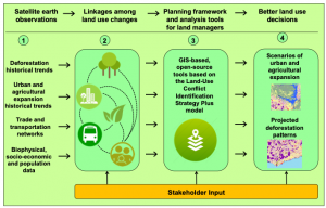
NSF: DISENTANGLING CROSS-SCALE INFLUENCES ON TREE SPECIES, TRAITS, AND DIVERSITY FROM INDIVIDUAL TREES TO CONTINENTAL SCALES
Nelms Institute Contact: Aditya Singh
Develops AI-based techniques to utilize airborne hyperspectral and hyperspatial imagery to investigate environmental controls on tree species structure and distributions across the continental United States.
CPS: MEDIUM: COLLABORATIVE RESEARCH: ROBUST AND INTELLIGENT OPTIMIZATION OF CONTROLLED-ENVIRONMENT AGRICULTURE SYSTEM FOR FOOD PRODUCTIVITY AND NUTRITIONAL SECURITY
Nelms Institute Contact: Aditya Singh
Operation control optimization and automation for growing nutrient rich produce from recycled graywater in containerized hydroponic systems.
LANDSCAPES IN FLUX: THE INFLUENCE OF DEMOGRAPHIC CHANGE AND INSTITUTIONAL MECHANISMS ON LAND COVER CHANGE, CLIMATE ADAPTABILITY AND FOOD SECURITY IN RURAL INDIA
Nelms Institute Contact: Aditya Singh
This project combines household-scale surveys and regional-scale socioeconomic data with remote sensing imagery to assess the causes and consequences of land cover change and food insecurity in India.