Dr. Zhe Jiang joined UF in August 2021 as assistant professor in the department of Computer & Information Science & Engineering (CISE), also affiliated with Warren B. Nelms Institute for the Connected World. His broad research areas are data science and artificial intelligence, with a particular focus on geospatial and spatiotemporal data in the context of interdisciplinary applications in Earth sciences, agriculture, transportation, public health, and public safety. He was an assistant professor at the University of Alabama before joining UF. Dr. Jiang’s research has been sponsored by the NSF, NOAA, USGS, and UCAR. He received his Ph.D. in computer science from the University of Minnesota in 2016.
Dr. Jiang’s recent research lies in an emerging field of GeoAI. Over the last decade, AI and deep learning technologies have revolutionized society with tremendous success in computer vision and natural language processing applications. With a large volume of geospatial and spatiotemporal data being collected from various sources (e.g., GPS trajectories, Earth observation imagery, ground sensor observations, geosocial media, and climate model simulations), there is a growing anticipation of the same level of accomplishment of AI in Geo-domains (a.k.a. GeoAI). However, GeoAI faces unique challenges such as spatial and temporal autocorrelation, heterogeneity, multiple scales and resolutions, domain physics and constraints, and the paucity of ground truth. Dr. Jiang’s lab is actively investigating cutting-edge GeoAI models, algorithms, and tools to address these challenges.
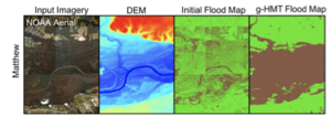
For example, one of his ongoing projects studies novel terrain-aware spatial machine learning model for observation-based riverine flood inundation mapping from satellite images. Dr. Jiang’s team developed a geographical Hidden Markov Tree (HMT) model, a probabilistic graphical model tying similar space and topography in the same way that a human analyst visually “assumes” the continuity and connectivity of flood points with similar or lower topography and through obscured views. Unlike existing methods for flood extent mapping from satellite images based on image classification, the HMT model explicitly incorporates the topography constraints to overcome image noise and obstacles (e.g., tree canopies), as shown in the figure below. His team is collaborating with researchers from NASA, USGS, NGA, and NOAA to deploy the tool to generate flood map data products for real-world flood disaster response and the validation of the NOAA National Water Model.
In his own words,
“My career passion is to explore interdisciplinary AI research that not only advance machine learning (deep learning) foundations but also make transformative impacts in addressing grand societal challenges. The Warren B. Nelms Institute for the Connected World and the university-wide AI initiative at UF provide rich research opportunities to investigate innovative AI techniques for spatiotemporal data. I am looking forward to learning from and collaborating with other researchers affiliated with the institute on AI for IoT applications.”
An Announcement:
Dr. Jiang’s lab has several open Ph.D. positions related to Interdisciplinary Data Science and AI. For details, please visit this webpage: http://www.jiangteam.org/prospective.html